10.1 North and Central Eurasia: A Continent Masquerading as a Region
10.1 North and Central Eurasia: A Continent Masquerading as a Region
How do distance, continentality, frozen ground, rivers, mountains, and water scarcity shape a region that stretches from eastern Europe to the Pacific?
Board the Trans-Siberian Railway in Moscow and the first lesson is not scenery. It is duration.
The train moves east through cities, birch forests, industrial towns, rivers, farms, and long intervals where the horizon seems to have misplaced the next settlement. Time zones accumulate. Europe recedes, although no coastline announces that Asia has begun. After days rather than hours, the railway reaches Lake Baikal and continues toward the Russian Far East. A map can compress this journey into a line. The body cannot.
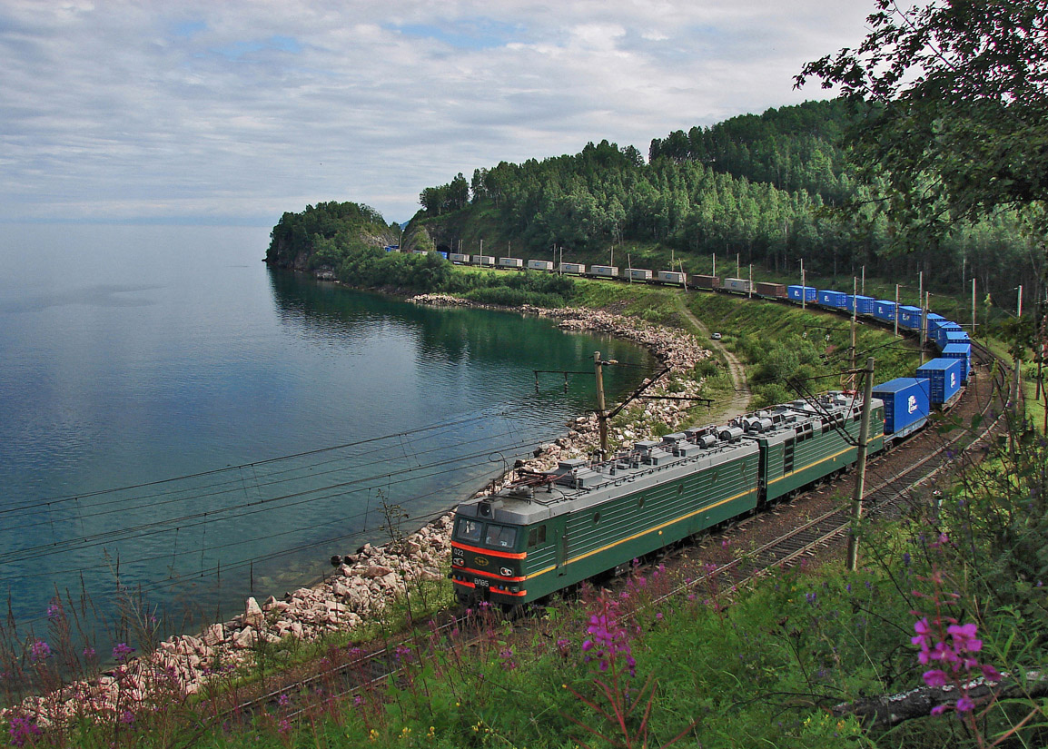
North and Central Eurasia is a region in which distance has repeatedly become a political problem. Armies had to cross it. Grain had to move across it. Nomadic communities learned to use movement rather than resist it. Imperial governments built forts, railroads, canals, pipelines, collective farms, mining settlements, and industrial cities to make distant territory governable. Soviet planners sometimes moved factories thousands of kilometers and populations against their will. After 1991, new international borders cut through transportation grids and economic relationships that had been designed for one state.
The region in this chapter includes Russia, Ukraine, Belarus, Moldova, Georgia, Armenia, Azerbaijan, Kazakhstan, Kyrgyzstan, Tajikistan, Turkmenistan, and Uzbekistan. They do not form a single civilization, political alliance, or environmental zone. The label North and Central Eurasia is useful because these states share overlapping imperial histories, Soviet legacies, transportation systems, migration routes, and environmental problems. It becomes misleading when Russia is treated as the center and everyone else as a peripheral “former Soviet republic.” A country is not a former anything to the people trying to build its present.
One line across a continental state
The moving dash follows the Trans-Siberian route from Moscow toward Vladivostok. The geography is real; the route is simplified between major stops.
Before you read: what does size cost?
Russia’s enormous territory can provide resources and strategic depth. What is the geographic cost that follows most directly from that same size?
The Tyranny and Possibility of Distance
Russia is the world’s largest country by area. That fact is familiar enough to become almost meaningless. Students see a vast shape stretched across the top of a map and assume that size itself is power. It can be. Size can provide minerals, forests, farmland, energy resources, strategic depth, and access to several seas. It can also demand roads, railways, communications, heating systems, military logistics, and public services across immense distances. Territory is an asset that sends maintenance bills.
The region extends from the Baltic and Black seas to the Pacific and from the Arctic Ocean south toward Afghanistan, Iran, and China. No single environmental description can contain it. Arctic tundra gives way to boreal forest, mixed forest, forest-steppe, grassland, agricultural zones, dry basins, and deserts. The Caucasus, Tian Shan, and Pamir mountains interrupt those broad latitudinal patterns. Elevation can create alpine conditions far south of the Arctic.
Even today, Russia’s population, institutions, and transportation networks remain concentrated heavily in the European portion of the country and along southern corridors. Siberia is not empty. It is expensive to connect.
Central Asia presents a different geometry. All five Central Asian states are landlocked, and Uzbekistan is one of only two doubly landlocked countries in the world. Freight leaving Uzbekistan for an ocean port must cross at least two national borders. Every border can add inspection, fees, paperwork, delay, political risk, or closure. Geography does not prevent trade. It raises the price of friction.
Interactive: Make Distance Governable
There is no magic infrastructure. Choose a setting, then choose what you would fund first. The point is to discover what each technology solves and what it leaves unsolved.
Continentality: When the Ocean Is Far Away
Much of North and Central Eurasia has a strongly continental climate. Water warms and cools more slowly than land, so oceans tend to soften seasonal temperature swings. Deep in a continent, summers can become surprisingly hot and winters severe.
Siberia supplies some of the most dramatic examples. In parts of the interior, average January temperatures fall below −40°C. The cold is not simply a number on a weather map. Metal becomes brittle. Batteries lose power. Engines require special care. Buildings, pipelines, roads, and rail beds must be designed for freezing, thawing, and frost movement. A winter road across frozen ground may function for months and then disappear into mud or water.
Central Asia is also continental, but latitude and elevation rearrange the pattern. Kazakhstan has cold winters and hot summers across much of its steppe. Uzbekistan and Turkmenistan contain extensive deserts with intense summer heat and limited precipitation. Kyrgyzstan and Tajikistan rise into the Tian Shan and Pamir, where high elevation produces cold conditions, glaciers, and abrupt climate differences over short distances.
Continentality is an explanation, not a substitute for local geography. The Caspian Sea modifies nearby climates. Mountains redirect winds and precipitation. Irrigation changes local humidity and vegetation. Cities create heat islands. Nobody actually lives inside a climate category.
Tundra
Cold, short growing seasons, widespread permafrost, low vegetation, migratory wildlife, and highly specialized human knowledge.
Taiga
The great boreal forest belt: timber, carbon storage, fire, wildlife, and immense distances between settlements.
Steppe
Grasslands of pastoral mobility, grain farming, armies, trade, and long-distance exchange between Europe and Asia.
Desert
Karakum and Kyzylkum landscapes of grazing, irrigated oases, mines, gas fields, cities, and trade routes rather than “empty” space.
The tundra lies across the far north. South of it is the taiga, the largest forest belt on Earth. Farther south, the steppe crosses southern Russia, Ukraine, and Kazakhstan. Its openness supported herds and crops, but also movement: technologies, religions, armies, and peoples traveled through it. The steppe was never an empty interval between civilizations. It was one of the systems connecting them.
Farther south and east, aridity becomes more prominent. The Karakum Desert covers much of Turkmenistan, while the Kyzylkum extends across Uzbekistan and Kazakhstan. Deserts contain settlements, roads, grazing lands, irrigated agriculture, mines, gas fields, and long histories of exchange. Calling them empty usually means the observer has not learned what to look for.
Permafrost: Ground That Keeps a Memory of Cold
Permafrost is ground that remains at or below freezing for at least two consecutive years. It can contain soil, rock, sand, organic material, and large amounts of ice. Above it, an active layer freezes and thaws with the seasons. Across northern Russia, communities and engineers built on the expectation that the deeper ground would remain frozen.
Climate change is altering that expectation. Where ice-rich permafrost thaws, the ground can settle unevenly. Roads buckle, foundations shift, pipelines bend, drainage changes, and landslides can begin. Thaw also exposes old organic material to decomposition, releasing carbon dioxide and methane. The result is a feedback: warming thaws frozen ground, and thaw can release additional greenhouse gases that contribute to further warming.

Permafrost is not scenery
It functions simultaneously as foundation, habitat, water-control layer, archive, and carbon store.
- Ice-rich ground can collapse when it thaws.
- Roads, railways, buildings, airports, and pipelines may require expensive adaptation.
- Frozen organic matter contains carbon that can re-enter the atmosphere after thaw.
- Communities also rely on frozen ground for travel, food storage, and seasonal access.
Norilsk illustrates why climate hazards should not be separated from infrastructure and institutions. In May 2020, a fuel tank near the Arctic industrial city failed and released about 21,000 cubic meters of diesel, roughly 17,500 tonnes. Research on the accident points to a combination of foundation and engineering problems, unusually warm conditions, and possible permafrost-related ground instability rather than one simple cause. Maintenance, design, industrial history, and warming ground met in the same accident. Climate change rarely acts alone.
Rivers That Flow the “Wrong” Way
Several of Russia’s great rivers flow north into the Arctic Ocean, including the Ob, Yenisei, and Lena. On a physical map this seems ordinary. In spring, however, southern parts of a river may thaw before northern parts. Water moving north can encounter ice, creating jams and floods. The rivers also run away from many of the country’s densest population centers and traditional trade partners.
The Volga follows a different path. It drains south into the Caspian Sea and has long served as a central artery of European Russia. Canals connect it with other river systems and seas, turning it into an engineered transportation network as well as a river. Cities, factories, reservoirs, farms, and cultural histories line its course.
The Dnieper flows through Russia, Belarus, and Ukraine before reaching the Black Sea. Dams and reservoirs made it central to Soviet electricity, industry, irrigation, and navigation. War turned this infrastructure into a target and a weapon. The destruction of the Kakhovka Dam in June 2023 flooded downstream settlements, drained the reservoir, damaged ecosystems and agriculture, and transformed water access. A river system built to bind territory together became part of the geography of invasion.
In Central Asia, major rivers begin largely in the mountains. The Amu Darya and Syr Darya carry snowmelt and glacier water toward the Aral basin. Upstream storage and downstream irrigation therefore connect countries physically before governments negotiate anything politically. We will return to the water-energy bargain in Section 10.4; here the essential geographic point is simpler: the source of water and the place of greatest demand are often not the same place.
Follow the water
The glowing dashes show direction of flow. The highlighted lines are schematic; the pale network underneath is omitted here to keep the directional lesson readable.
Lake Baikal, the Caspian Sea, and the Aral Sea
The region contains three inland waters that are easy to remember as superlatives and more useful to understand as systems. Lake Baikal is the world’s oldest and deepest lake and holds nearly one-fifth of the world’s unfrozen surface freshwater. The Caspian is the world’s largest enclosed inland body of water. The Aral Sea became one of the twentieth century’s starkest examples of environmental destruction caused by large-scale water diversion.

Lake Baikal
Its isolation and age helped produce extraordinary endemism, including the Baikal seal. The more revealing question is how a globally important ecosystem coexists with tourism, shoreline development, pollution, fire, logging pressure, and local economic needs.
The Aral Sea story is often compressed into the sentence “the sea disappeared.” The reality is more revealing. Soviet planners expanded irrigated cotton and other crops by diverting the Amu Darya and Syr Darya. Beginning in the 1960s, the sea shrank dramatically. Fishing towns found themselves far from water. Exposed lakebed sediments carried salts and pollutants in dust storms. Fisheries collapsed and public health suffered.
But the water body fragmented rather than vanishing uniformly. In Kazakhstan, the Kok-Aral Dam helped retain water in the North Aral Sea. Water levels rose, salinity declined, and some fisheries returned. Much of the southern basin remains exposed. The Aral therefore gives us two lessons at once: environmental destruction can be enormous, and damaged geography is not always beyond partial repair.
Climate Change Does Not Arrive Alone
The Arctic is warming far faster than the planet as a whole. Sea ice has declined, glaciers have lost mass, permafrost is warming, and tundra vegetation is changing. NOAA’s 2025 Arctic Report Card found that circumpolar maximum tundra greenness was the third highest in the 26-year MODIS satellite record, continuing a run of record or near-record values since 2020. “Greener” does not mean healthier or more stable; fires, abrupt thaw, hydrologic change, and local browning occur within the larger trend.
Central Asia faces a different combination of rising heat, glacier loss, drought, flood risk, and water stress. A 2025 UNEP atlas reported that Uzbekistan has warmed far faster than the global average over recent decades, with increases reaching about 2.5°C around the Aral region, and recorded six dry years between 2019 and 2024. Mountain glaciers may initially add meltwater and later provide less as ice volume declines. Hotter summers can raise agricultural demand just as water becomes less predictable.
Climate change enters an inherited landscape
It does not arrive on a blank map. It enters Soviet irrigation canals, aging apartment blocks, permafrost foundations, reservoirs, industrial sites, disputed borders, and economies dependent on fossil fuels.
The hazard may be physical. The disaster is assembled socially. A warming climate matters differently where foundations were designed for frozen ground, where irrigation already consumes most available water, where industrial pollution has accumulated for decades, or where war has damaged the infrastructure that once reduced risk.
Check your geography
Choose the best answer for each question. These are deliberately about the argument of the reading, not trivia.
1. Why does the chapter call Siberia “expensive to connect” rather than “empty”?
2. Why can spring flooding be especially troublesome on north-flowing Siberian rivers?
3. What makes permafrost part of the built environment?
4. What is the most accurate lesson from the Aral Sea?
Main Points
- North and Central Eurasia is connected by imperial and Soviet legacies, but it is not a single cultural, political, or environmental unit.
- Enormous territory can provide resources and strategic depth while simultaneously raising the cost of transportation, communications, defense, heating, and public services.
- Continentality helps explain the region’s large seasonal temperature ranges, but latitude, elevation, mountains, inland waters, and local land use create major regional differences.
- Permafrost is part of the region’s infrastructure. Thaw can destabilize foundations, roads, railways, pipelines, drainage, and other systems built around formerly frozen ground.
- River direction matters. Major Siberian rivers flow toward the Arctic, the Volga toward the Caspian, the Dnieper toward the Black Sea, and Central Asian rivers toward inland basins where upstream water and downstream demand cross national borders.
- Lake Baikal, the Caspian Sea, and the Aral Sea show three different relationships between water and society: ecological uniqueness, a shrinking enclosed basin, and catastrophic diversion followed by partial restoration.
- Climate change acts through landscapes already shaped by irrigation systems, permafrost engineering, reservoirs, industrial pollution, settlement patterns, and war. Physical hazards and social vulnerability cannot be separated.
Key Terms
Works Cited
- National Oceanic and Atmospheric Administration. 2025. “Tundra Greenness.” Arctic Report Card 2025. NOAA Arctic.
- United Nations Environment Programme. 2025. “Climate Change Drives Rising Temperatures and Severe Drought in Uzbekistan.” UNEP.
- United Nations Environment Programme. 2026. “The Race to Save the Vanishing Caspian Sea.” UNEP.
- National Snow and Ice Data Center. “Why Frozen Ground Matters.” NSIDC.
- United Nations Environment Programme. 2023. Rapid Environmental Assessment of Kakhovka Dam Breach, Ukraine, 2023. UNEP.
- Rajendran, Sankaran, et al. 2021. “Monitoring Oil Spill in Norilsk, Russia Using Satellite Data.” Scientific Reports 11:3817. Nature.
- UNESCO World Heritage Centre. “Lake Baikal.” UNESCO.
- Fouberg, Erin H., and William G. Moseley. 2018. Understanding World Regional Geography. 2nd ed. John Wiley & Sons.
Further Reading
- NOAA. Arctic Report Card 2025. A broader overview of rapid environmental change across the Arctic. NOAA Arctic.
- UNEP. Atlas of Environmental Change: Uzbekistan. Current satellite-based context for drought, warming, land, and water change in Central Asia. UNEP.
- UNESCO World Heritage Centre. “Lake Baikal.” Background on the lake’s ecological importance, endemism, and conservation challenges. UNESCO.


Comments
Post a Comment