12.1 South America, Mesoamerica, and the Caribbean A Continent Built in Motion
A Continent Built in Motion
Before conquest, plantations, independence, factories, or tourism, there was motion: plates descending, mountains rising, water climbing into the atmosphere, rivers crossing borders, and people learning how to live inside systems that never really stood still.

By the end of this section, you should be able to:
- Explain why South America, Mesoamerica, Latin America, the Caribbean, and North America overlap rather than forming perfectly separate regional boxes.
- Connect plate tectonics and Andean elevation to hazards, settlement, agriculture, transportation, mineral belts, and water supply.
- Explain how Amazon forests participate in the water cycle and how Indigenous land management, deforestation, and agricultural intensification complicate simple ideas about tropical environmental limits.
- Use Hadley circulation, the ITCZ, ENSO, tropical cyclones, and climate vulnerability to distinguish large-scale atmospheric processes from the social conditions that turn hazards into unequal disasters.
Regions Are Tools, Not Boxes
Mexico belongs to North America. It also belongs to Latin America. Southern Mexico and neighboring parts of Central America belong to Mesoamerica, a cultural region whose history long predates either label. The Caribbean belongs to the Atlantic world, the Americas, and several linguistic and imperial worlds at once. Guyana and Suriname are on the South American continent but are often connected culturally and politically with the Caribbean. Puerto Rico is a Caribbean island and a territory of the United States.
If these statements seem untidy, good. Regions are tools, not boxes built by nature.
The term Latin America usually refers to societies in the Americas where Spanish, Portuguese, or French became dominant through European colonization. The name draws attention to a shared colonial history, but it can also hide a great deal. Millions of people speak Quechua, Guaraní, Aymara, Nahuatl, Maya languages, Mapudungun, Kreyòl, Dutch, English, and hundreds of other languages. African-descended societies have shaped the region from Brazil to Cuba and from Colombia to the Dominican Republic. Indigenous nations did not become “Latin” simply because an empire arrived.
The label is therefore useful only if we keep asking what it leaves out.
A cheerful travel guide might begin with colonial plazas, rainforest lodges, Andean railways, Caribbean beaches, tango in Buenos Aires, samba in Rio, tacos in Mexico City, and coffee farms beneath volcanoes. All of those things are real, and there is no virtue in pretending beauty is merely propaganda. A beach can be magnificent. A meal can tell the truth about a place more quickly than a ministerial speech.
But the geography changes when we ask a second set of questions. Who owns the shore behind the resort? Who washes the hotel sheets? Where did the coffee price come from? Why does a colonial plaza look European when the people crossing it may be Indigenous, African-descended, mestizo, Asian, or all of these at once? Why does copper leave through one port, soy through another, and migrants through a third corridor? The postcard is not false. It is incomplete.
This region was connected to the world very early in the modern global economy. Silver from Potosí crossed oceans. Sugar from Caribbean plantations sweetened European tea. Guano from Peru fertilized distant farms. Bananas, coffee, rubber, copper, oil, beef, soy, lithium, factory parts, tourism, and remittances followed. Connection brought investment, technology, cities, and opportunity. It also created landscapes organized to move wealth outward.
The question running beneath the chapter is not whether the region is connected. It is connected on whose terms.
The Mountains Are Still Arriving
South America looks solid on a map. Along its western edge, however, the continent is being remade.
The oceanic Nazca Plate moves beneath the South American Plate along a subduction zone. As oceanic crust descends, fluids released from the slab help generate magma in the mantle above while compression uplifts, fractures, and folds the continental margin. Over immense spans of time this process built the Andes, one of the world's great mountain systems. In human time it produces earthquakes, volcanoes, landslides, mineral deposits, and the steep environmental gradients upon which millions of people live.
Mesoamerica and the Caribbean are also tectonically active. The Cocos Plate descends beneath parts of Mexico and Central America, feeding a chain of volcanoes. The Caribbean Plate moves among larger neighboring plates along a complicated set of boundaries. Haiti's devastating 2010 earthquake did not occur because the country was cursed. It occurred where tectonic strain met weak construction, dense settlement, poverty, and limited state capacity. The hazard came from geology. The disaster was geographical.
Students sometimes treat earthquakes as moments when nature interrupts society. In this region, society has always been built within tectonic motion. Volcanic soils support productive agriculture. Highland basins concentrate settlement. Mineral belts attract mines and railways. Steep slopes create isolation, biodiversity, and landslide risk. A volcano can destroy a town and help feed the farms around it.
Tectonic Motion Atlas
Switch regions. The maps are real plate-boundary maps; the moving arrow beneath each map is a simplified process cue, not a second map.

Andes: Nazca beneath South America
Watch the boundary: convergence compresses and deforms the continental edge, helping produce uplift, volcanism, and major earthquakes.
Human geography: the same mountain-building system creates hazards, water towers, steep settlement gradients, and mineral belts.
Mexico City offers a particularly revealing case. The Aztec capital of Tenochtitlan stood on islands and engineered land within Lake Texcoco. Spanish conquerors rebuilt the city while draining much of the lake. The modern metropolis now presses downward on soft lake sediments while groundwater extraction causes parts of the ground to sink. Earthquake waves can be amplified by those sediments. A decision made during conquest remains present in the behavior of the ground.
Physical geography is not a stage built before history begins. It keeps acting, and history changes the way its actions are felt.

The Andes Turn Distance Vertical
On a flat map, Quito and the Amazon lowlands seem fairly close. In lived geography they occupy different worlds.
Elevation changes temperature, moisture, vegetation, crops, transportation, and disease environments. Geographers once described the tropical Andes through simplified elevation zones: tierra caliente, or hot land; tierra templada, temperate land; tierra fría, cold land; and still higher zones of grassland, rock, and ice. The boundaries vary with latitude, slope, exposure, and local climate, but the idea remains useful. In the tropics, climbing a mountain can resemble traveling from the equator toward the poles.
Farmers have long used this vertical diversity. Households and communities exchanged potatoes, maize, quinoa, coca, fruits, wool, salt, and other products across elevation zones. The Inca state expanded these older networks through roads, storehouses, terraces, labor obligations, and administrative centers. It did not conquer an empty wilderness. It organized landscapes already known intimately by many peoples.
Spanish colonial rule redirected parts of the vertical economy toward mines, estates, and imperial cities. Modern roads, mines, dams, airports, and export agriculture added new connections. Yet elevation still sets prices. A school, clinic, or market can be geographically close and practically distant when a ridge, ravine, or rainy season lies between.
The Andes also function as a water tower. Snow, glaciers, wetlands, and high-elevation grasslands store and release water to cities, farms, hydropower systems, and ecosystems. Glacier retreat therefore affects more than scenic beauty. The World Meteorological Organization reported accelerating glacier retreat across the region in 2025 alongside record heat, drought, floods, tropical cyclones, and rising seas. A shrinking glacier changes the timing and reliability of water far downstream.
Mountains turn climate into infrastructure.
Classic Andes elevation zones
This diagram keeps the old geography vocabulary but makes it visible at a glance. The bands are deliberately simplified: real boundaries shift with latitude, slope, rainfall, and local microclimate.

Tierra caliente 0–900 m
Climate: warm tropical lowlands.
Common crops and uses: cacao, bananas, cassava, tropical fruits, lowland pasture, and forest livelihoods.
Distance changes: river routes and lowland roads may matter more than mountain passes, though heat and flooding still shape movement.
Tierra templada 900–1,800 m
Climate: milder middle-elevation tropical conditions.
Common crops and uses: coffee, maize, fruit, and diversified farming on many suitable slopes and valleys.
Distance changes: roads begin to climb and bend; short horizontal distances can already produce big environmental contrasts.
Tierra fría 1,800–3,200 m
Climate: cooler tropical highland conditions.
Common crops and uses: potatoes, quinoa, maize in suitable valleys, grazing, and dense highland settlement.
Distance changes: steeper roads and mountain passes make a geographically nearby school, market, or clinic feel much farther away.
Puna / páramo 3,200–4,100 m
Climate: cold, windy high-elevation grassland and wetland environments.
Common crops and uses: pastoralism, hardy tubers and grains in suitable places, extensive grazing, and wetland use.
Water role: these high grasslands and wetlands store and release water to lower elevations.
Rock, snow, and ice 4,100 m +
Climate: freezing conditions increasingly common.
Common uses: little or no cropping; mountaineering, mining, and grazing at lower edges, while snow and glaciers act as water storage.
Why it matters: glacier retreat changes the timing and reliability of downstream water supplies.
The Forest Makes Rain Twice
The Amazon is often described as the world's largest tropical rainforest. It is also a river system, an atmospheric system, an Indigenous homeland, a biological archive, and a contested economic frontier.
Moisture enters from the tropical Atlantic. Trade winds carry it westward. Forests return enormous quantities of water to the atmosphere through evaporation and transpiration, the release of water by plants. That moisture can fall again as rain, then return to the air and travel farther. The forest therefore helps recycle and transport water across the continent. Air rises against the Andes, feeding rainfall and rivers that flow back eastward through the basin.
This is why deforestation is not merely a local change in land cover. Remove enough forest and the effects can travel through the water cycle. Pasture or cropland may release less moisture, become hotter, burn more easily, and alter rainfall downwind. Forests and farms are sometimes presented as competitors for the same land. In reality, agriculture depends on atmospheric services that forests help sustain.
Follow the Water
Switch the land-cover state. The diagram is schematic: it shows the direction of processes, not a forecast of exactly how much rainfall changes at a particular location.
The rainforest is not uniformly fertile. Heavy rainfall and rapid decomposition can move nutrients quickly through vegetation while leaving many soils relatively poor. Clear the forest and a temporary pulse of nutrients may support crops or pasture, but fertility can decline. This helped older textbooks portray the Amazon as a place where substantial settlement was almost impossible.
Archaeology and soil science corrected that story. Indigenous peoples managed forests, planted useful species, built earthworks, fished rivers, moved along trade networks, and created patches of exceptionally fertile terra preta, or dark earth, by adding charcoal, food waste, bone, and organic matter. These soils are not evidence that environmental limits were imaginary. They are evidence that knowledge can alter limits over generations.
The forest that Europeans called wild often contained the work of human hands.

Old assumption
Thin tropical soils meant that complex or durable human landscapes in Amazonia must have been extremely limited.
What the evidence changed
Archaeology, earthworks, useful plant distributions, and anthropogenic soils reveal long histories of management, settlement, exchange, and ecological knowledge.
Food, Population, and the Mistake of One-Way Causation
Thomas Malthus argued that population tends to grow faster than food supply, making famine a recurring check on human numbers. The insight that resources are finite remains important. The mistake is to imagine that food production never changes in response to population, institutions, prices, or knowledge.
Ester Boserup reversed the direction of the question. Population pressure, she argued, can encourage people to intensify agriculture by terracing slopes, improving irrigation, shortening fallow periods, adding labor, and developing new techniques. Precolonial chinampas in the Basin of Mexico, Andean terraces, raised fields in wetlands, and Amazonian dark earth all demonstrate that food systems are historical achievements rather than fixed gifts of climate.
Malthus asks
What happens when population grows faster than a limited food supply? The emphasis is on ecological limits and the danger of scarcity.
Boserup asks
How might population pressure change labor, technique, irrigation, terracing, and the intensity with which land is used? The emphasis is on adaptation and innovation.
Neither Malthus nor Boserup explains every case. Hunger can occur when food exists but people lack income, land, transportation, or political power. Export agriculture can generate national revenue while nearby households face malnutrition. A drought becomes famine only through social conditions that determine who can obtain food.
That distinction matters in a region that exports enormous quantities of soy, beef, fruit, coffee, sugar, and fish. Production and nourishment are related, but they are not the same geographical outcome.
Rain Has a Seasonal Geography
Much of tropical Latin America receives energy from an intense sun, but rainfall varies enormously.
The Hadley Engine: Move the Sun Through the Year
Drag the calendar from January to December. Watch the zone of strongest tropical heating and convergence migrate north and south, carrying the main rising branch of the Hadley circulation with it. The positions are schematic, not a daily weather forecast.
Near the equator, rising warm air and the seasonal movement of the Intertropical Convergence Zone (ITCZ) help produce frequent rainfall. Farther north and south, the annual migration of this rain belt contributes to wet and dry seasons. Mountain barriers create wet windward slopes and dry rain shadows. Cold ocean currents stabilize air along parts of the Pacific coast, contributing to the extreme dryness of Peru's coastal desert and the Atacama Desert of northern Chile. Warm Caribbean and tropical Atlantic waters supply moisture to storms.
The El Niño-Southern Oscillation (ENSO) links the region to changes across the tropical Pacific. During El Niño, unusually warm surface waters in the eastern and central Pacific shift atmospheric circulation. Some areas become wetter, others drier, fisheries can be disrupted, and flood or fire risk changes. La Niña usually produces a different pattern, but neither phase creates identical effects everywhere.
The useful lesson is not to memorize “El Niño equals rain” or “La Niña equals drought.” Climate teleconnections rearrange probabilities across a varied landscape.
ENSO: Switch the Pacific
These NOAA/NESDIS maps show the ocean-temperature pattern that helps define the two phases. They are not rainfall maps, which is precisely the point.

Warmer-than-usual equatorial Pacific waters alter convection, winds, and atmospheric circulation. The consequences differ by season and location across Latin America and the Caribbean.
What to remember: ENSO changes odds. It does not issue one weather command to an entire continent.
Tropical cyclones add another geography of risk. Warm ocean water can feed hurricanes that cross the Caribbean, strike island societies, and reach Mexico or Central America. Wind speed matters, but so do building quality, elevation, evacuation routes, public trust, insurance, debt, and the ability to restore electricity. A wealthy visitor may leave before a storm. A hotel may rebuild faster than the homes of its workers.
The World Meteorological Organization's 2026 regional climate report emphasized the combination of record heat, a more extreme water cycle, devastating tropical cyclones, glacier retreat, and threats to food systems in 2025. Climate change is not one hazard added to the list. It changes the background conditions within which many hazards operate.
The Amazon Is Not One National Decision
The Amazon basin spans eight countries and French Guiana. Brazil contains the largest share, but rivers, smoke, rainfall, wildlife, markets, and Indigenous territories cross national borders.
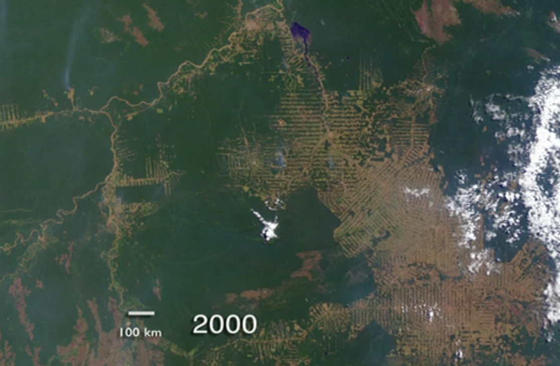
Deforestation has many causes. Roads open access. Land speculation rewards clearing. Cattle ranching occupies large areas. Soy production expands through direct clearing in some places and by displacing other land uses in others. Mining, logging, dams, fire, and urban growth create additional pressures. Global consumers participate through commodity markets, but national law, local enforcement, credit, land tenure, and political conflict determine how those pressures become landscapes.
The trend is not simply one of inevitable destruction. Brazil's National Institute for Space Research (INPE) reports a consolidated 2025 clear-cut deforestation rate of 5,731 square kilometers in the Legal Amazon, 12.07 percent below 2024. That decline matters. So does the fact that thousands of square kilometers were still cleared.
Satellite monitoring has made disappearance visible almost in real time. Visibility, however, does not decide what happens next. Governments can enforce law or weaken it. Banks can screen loans. Companies can trace supply chains or hide behind intermediaries. Communities can gain secure land rights or face invasion.
Watch the fishbone pattern grow
Click between the two years. Roads become the skeleton, then side clearings multiply along them.
Indigenous and tribal peoples are involved in communal governance of between 320 and 380 million hectares of forest across Latin America and the Caribbean. More than 80 percent of the area occupied by Indigenous peoples is forest-covered, according to evidence summarized by the Food and Agriculture Organization and the Fund for the Development of Indigenous Peoples of Latin America and the Caribbean. This does not mean Indigenous people are decorative guardians placed outside modern life. It means territorial rights and functioning local institutions often conserve forests more effectively than distant promises.
The Amazon's future will be decided through property, law, roads, elections, consumption, and power as surely as through rainfall.
Climate Change Arrives Through Inequality
Latin America and the Caribbean contain nearly every major climate exposure: melting mountain ice, drought, extreme rain, wildfire, coastal flooding, heat, and tropical cyclones. Yet exposure is not destiny.
A family living on a stable, serviced hillside experiences heavy rain differently from a family in an informal settlement on a steep cut slope. A hotel with generators and insurance experiences a hurricane differently from a fishing household. A commercial farm can drill deeper wells or buy irrigation equipment that a smallholder cannot afford. An Indigenous community may protect a forest while lacking legal defense against outsiders.
The phrase climate vulnerability describes this meeting of environmental hazard and social capacity. Poverty can increase vulnerability, but wealth alone does not guarantee wisdom. Expensive coastal development can create enormous future losses. A dam can reduce one risk while creating another. Air conditioning protects individuals while increasing electricity demand. Adaptation always has a geography of who pays, who benefits, and who is moved.
Same heavy rain, different hillside
Drainage, legal tenure, slope stability, road access, emergency response, and building quality can turn the same storm into inconvenience in one neighborhood and disaster in another.
Same hurricane, different household
Insurance, savings, evacuation options, generators, political influence, and the speed of utility restoration distribute recovery unevenly.
Same drought, different farm
Credit, irrigation, wells, crop insurance, land ownership, and market power determine who can adapt and who must sell land or migrate.
Same forest, different authority
Communities may possess deep ecological knowledge yet remain vulnerable if legal systems fail to defend territorial rights against logging, mining, or land invasion.
The physical region is spectacular because it is active. Plates move. Water circulates. Forests breathe. Oceans exchange heat with the atmosphere. Human beings have never stood outside these systems.
The next question is how conquest and culture reorganized who could command them.
What to carry forward
- Regions are analytical tools. Mexico, the Caribbean, the Guianas, South America, Mesoamerica, and Latin America overlap through different physical, cultural, and political definitions.
- Plate boundaries continue to build and shake the region. Tectonic hazards become disasters through settlement, construction, poverty, infrastructure, and state capacity.
- The Andes compress horizontal distance into vertical environmental zones. Elevation reorganizes crops, temperature, transportation, settlement, and the timing of water supplies.
- The Amazon is simultaneously a forest, river basin, atmospheric water-recycling system, Indigenous homeland, and political-economic frontier. Changing land cover can affect places far beyond the cleared parcel.
- Food systems are not fixed by nature. Malthus emphasizes ecological limits; Boserup emphasizes how population pressure can stimulate intensification and innovation; access to food also depends on income, land, transport, and power.
- Hadley circulation and the migrating ITCZ help organize tropical wet and dry seasons, while ENSO, ocean currents, mountains, and tropical cyclones further shift rainfall and hazard probabilities. No single climate rule fits every place.
- Amazon deforestation is neither inevitable nor solved. The consolidated 2025 PRODES rate fell to 5,731 square kilometers, while Indigenous territorial governance remains strongly associated with forest conservation.
- Climate vulnerability is social as well as physical. The same rainfall, drought, hurricane, or heat can produce very different outcomes depending on housing, rights, wealth, infrastructure, and political capacity.
Vocabulary for the section
- Latin America
- A broad historical-cultural label usually applied to American societies where Spanish, Portuguese, or French became dominant through colonization.
- Mesoamerica
- A cultural-historical region centered on central and southern Mexico and parts of Central America, with deep Indigenous histories predating modern borders.
- Subduction zone
- A plate boundary where one tectonic plate descends beneath another.
- Tierra caliente
- A simplified Andean term for warm tropical lowlands.
- Tierra templada
- A simplified Andean term for milder middle-elevation environments.
- Tierra fría
- A simplified Andean term for cooler tropical highlands.
- Transpiration
- The release of water vapor from plants, especially through leaves.
- Terra preta
- Anthropogenic Amazonian dark earth enriched by generations of human activity.
- Hadley cell
- A large-scale tropical circulation in which warm air rises near the ITCZ, moves poleward aloft, sinks in the subtropics, and returns near the surface as the trade winds.
- ITCZ
- The Intertropical Convergence Zone, a migrating belt of rising air and frequent rainfall near the equator.
- ENSO
- El Niño-Southern Oscillation, a recurring tropical Pacific ocean-atmosphere pattern that shifts climate probabilities around the world.
- Climate vulnerability
- The meeting of environmental exposure with social sensitivity and the capacity to prepare, cope, and recover.
- Legal Amazon
- A Brazilian planning and administrative region encompassing the Amazon states and adjoining areas used for environmental monitoring and policy.
Works cited and data sources
- Fouberg, Erin H., and William G. Moseley. Understanding World Regional Geography, 2nd ed. Wiley, 2018.
- World Meteorological Organization. State of the Climate in Latin America and the Caribbean 2025. May 18, 2026.
- Instituto Nacional de Pesquisas Espaciais. Consolidated PRODES 2025 Legal Amazon deforestation rate. 5,731 km², 12.07 percent below 2024.
- Food and Agriculture Organization of the United Nations. Forest governance by Indigenous and tribal peoples.
- U.S. Geological Survey. Seismotectonics of South America: Nazca Plate Region and Caribbean Plate and Vicinity.
- National Oceanic and Atmospheric Administration, National Weather Service JetStream. Global atmospheric circulations and the Hadley cell.
- National Oceanic and Atmospheric Administration. Understanding El Niño and ENSO.
Further reading
- Boserup, Ester. The Conditions of Agricultural Growth: The Economics of Agrarian Change under Population Pressure.
- Denevan, William M. “The Pristine Myth: The Landscape of the Americas in 1492.” Annals of the Association of American Geographers, 1992.
- Heckenberger, Michael J., and Eduardo Góes Neves. “Amazonian Archaeology.” Annual Review of Anthropology, 2009.
Visual credits: 1905 South America physical map and 1524 Tenochtitlan map, public domain via Wikimedia Commons; Andamarca terrace farmers, Goldengreenbird, CC BY-SA 3.0; terra preta soil profile, Rockwurm / ISRIC World Soil Information, CC BY-SA 3.0; plate maps via Wikimedia Commons; ENSO imagery, NOAA/NESDIS public-domain U.S. government imagery; Rondônia satellite imagery, NASA public domain.
The next section moves from physical systems into conquest, disease, slavery, language, race, religion, migration, and the new societies made under unequal colonial conditions.


Comments
Post a Comment