11.1 North America: The Continent Behind the Weather Map
The Continent Behind the Weather Map
North America can look almost too familiar to study. But watch a weather map for a few days and the continent begins to reveal itself: Pacific moisture colliding with mountains, Gulf air moving north, Arctic cold moving south, rivers ignoring political borders, and fires sending smoke across countries. The ordinary forecast is really a map of a continental machine.
By the end of this section, you should be able to:
- Explain how mountains, continentality, oceans, and major air sources help produce North America's climate patterns.
- Read the Great Lakes, Mississippi-Missouri, and Colorado systems as watersheds that cross political boundaries.
- Distinguish a physical hazard from the social vulnerability that helps turn hazards into disasters.
- Explain why the Arctic should be understood as an inhabited homeland as well as a rapidly changing physical region.
A Landmass with Several Edges
Look at North America from space and the first impression is continuity. A single landmass curves from Arctic ice to subtropical coasts. Mountain chains run like a raised spine along the west. Great lakes shine near the center. A green east gives way to browns and tans across the interior west.
Descend into the region and continuity breaks into thresholds. Rain forest can become dry interior within a surprisingly short trip east of the Coast Mountains. Prairie becomes boreal forest. Permafrost gives way to muskeg, farms, and cities. A political line may divide British Columbia from Washington, but it does not divide the Cascades, the Columbia River, salmon habitat, wildfire smoke, or an atmospheric river arriving from the Pacific.
Interactive: Follow the Air Across the Continent
The base is a real physical map of North America. Choose an air or moisture source to illuminate a schematic pathway across the continent. The moving lines show broad geographic movement rather than a particular day's weather forecast.

The oldest geological core is the Canadian Shield , a vast zone of ancient rock wrapped around Hudson Bay. Glaciers scraped it, exposed bedrock, and left thin soils and innumerable lakes. The Shield is rich in minerals but often difficult for agriculture. One result appears immediately on population maps: enormous northern territories with small and widely separated settlements, followed by a much denser southern band.
South and west of the Shield lie broad interior lowlands and plains. Some of the continent's most productive agricultural soils developed beneath grasslands and over glacial deposits. Farther west, the Rocky Mountains and related ranges form part of a much larger cordillera extending from Alaska through Canada and the United States into Mexico. These mountains are geologically younger than the Appalachians and decisive in the movement of air and water.
The eastern mountains tell another story. The Appalachians are older, lower, and more eroded. Their coalfields helped power industrialization, while their ridges guided settlement and transportation. The Atlantic and Gulf coastal plains contain wetlands, river deltas, farms, ports, and some of the continent's largest metropolitan regions.
Before the Satellite, There Was the Guess
The physical map above looks authoritative because generations of surveying, measurement, aerial photography, satellites, and geographic information systems lie behind it. Earlier cartographers had coastlines from sailors, fragments of rivers from travelers, Indigenous geographical knowledge filtered through European interpreters, competing imperial claims, and a considerable amount of uncertainty. Sometimes uncertainty remained blank. Sometimes it became geography.
Old Map Detective: North America in 1698
This is Louis Hennepin's real 1698 map. Choose a feature below. The map does not simply show North America. It shows what a European cartographer believed, borrowed, guessed, or hoped was there.

Why the West Is Dry
North American precipitation maps reveal one of the continent's great asymmetries. Much of the east is humid. Large parts of the interior and southwest are dry. The Pacific Northwest can be remarkably wet on its ocean-facing slopes and much drier just beyond them.
Moisture enters from the Pacific, Gulf, Atlantic, and Arctic. At middle latitudes, prevailing winds generally move weather from west to east. When moist Pacific air reaches coastal mountains and the western cordillera, it is forced upward. Rising air cools, water vapor condenses, and precipitation falls on the windward slopes. Descending air on the leeward side warms and dries, producing a rain shadow . A wet forest and a dry basin may therefore be separated by a mountain range rather than by hundreds of miles.
The Gulf of Mexico supplies moisture to the central and eastern United States. Warm, humid air can move far north across relatively open plains. Cold, dry air can move south from the Arctic and Canada, while warm dry air descends from the Rockies and deserts. Where contrasting air masses meet, the atmosphere becomes energetic. Thunderstorms, hail, tornadoes, blizzards, and abrupt temperature changes are not random insults. They are expressions of continental location.
Distance from the ocean matters as well. Continentality helps explain the enormous annual temperature range familiar across the northern plains and interior Canada. Oceans heat and cool relatively slowly. Interior land does not. A place can experience bitter winter cold and intense summer heat because no nearby ocean is smoothing the annual curve.
Ocean currents add another layer. The warm Gulf Stream influences the Atlantic margin while the cold California Current helps cool and stabilize parts of the Pacific coast. El Nino and La Nina begin in the tropical Pacific but can shift storm tracks and temperature patterns across North America. Changes thousands of miles away can alter snowpack in the Rockies, rainfall in California, drought on the plains, or winter conditions in Minnesota.

The lesson is not that one variable explains climate. Climate emerges from relationships among latitude, elevation, mountains, oceans, currents, prevailing winds, vegetation, and continental position. A precipitation map is the visible result of an atmospheric negotiation.
Water Makes the Region, Then Politics Divides It
North America contains immense freshwater resources, but abundance and availability are not the same thing. Water collects according to gravity and topography, not the boundaries of provinces, states, cities, or nations.
The Great Lakes contain about one-fifth of the world's surface fresh water, roughly 21 percent by current U.S. EPA figures. They support cities, industry, shipping, fisheries, recreation, and drinking-water systems in both the United States and Canada. They are not five isolated bowls. Water moves through a connected basin and ultimately reaches the Atlantic through the St. Lawrence River. Pollution released in one jurisdiction can travel to another. Invasive species do not present passports. The Great Lakes Water Quality Agreement recognizes that the lakes require binational governance.

The Mississippi-Missouri system drains much of the continental interior. Tributaries gather water from farms, cities, forests, and plains. Barges move grain, fertilizer, coal, and other goods. Levees and dams reduce some risks while redistributing others. Nutrients applied to distant farm fields can travel downstream and contribute to low-oxygen conditions in the Gulf.
A watershed turns actions on distant land into consequences in shared water. This is why a watershed map can tell a story that a political map conceals.
The Colorado River: Scarcity Is Physical, Shortage Is Governed
The Colorado begins in snowy mountains and crosses an arid region where cities and agriculture depend on water stored behind enormous dams. Its legal allocation was constructed during a wetter period and divided among states, Mexico, tribal nations, farms, cities, and other users through a dense web of agreements and court decisions.
Since 2000, the basin has experienced prolonged drought, declining storage, and warming that increases evaporation and reduces the fraction of snowmelt reaching the river. Describing the problem simply as too many people moving to the desert misses much of the geography. Agriculture consumes most of the river's water. Different crops require different amounts. Tribal nations possess major legal rights that were long ignored or underdeveloped. Cities have often reduced per-person consumption even while growing. The climate is changing the river itself.
Interactive: Lake Mead, Same Place, Different Water
Drag the control. These are real Landsat images acquired almost exactly twenty-two years apart.


This is a recurring North American pattern. The water is physical. The shortage is partly institutional. Nature determines how much water enters the system; law and politics determine many of the promises made against it.
Glaciers, Soils, and the Grid
During the last ice age, continental glaciers covered most of Canada and reached deep into the northern United States. Ice scraped bedrock, deepened basins, moved sediment, blocked rivers, and left behind lakes, ridges, wetlands, and fertile deposits. Minnesota's thousands of lakes are not decorative accidents. They are a glacial inheritance.
Glaciers also helped shape the agricultural geography of the interior. Windblown silt, glacial till, and grassland ecosystems produced deep soils across parts of the Great Plains and Midwest. Settler governments later imposed survey grids that divided land into standardized parcels. Seen from an airplane, roads and fields often form a checkerboard.
The grid looks rational and neutral, yet it rests on a profound transformation: Indigenous territories were converted into surveyed property that could be sold, taxed, fenced, granted to railroads, mortgaged, inherited, and farmed. Rivers, wetlands, bison ranges, seasonal movements, and sacred places did not necessarily fit the squares.
The Arctic Is Not Empty
On many classroom maps, northern Canada and Alaska appear as pale space above the real action. That visual habit is misleading. The Arctic contains Inuit, Inupiat, Gwich'in, Dene, Cree, and other communities whose lives are tied to sea ice, caribou, fish, marine mammals, seasonal travel, family networks, and generations of local knowledge.
It also contains military installations, mines, oil and gas infrastructure, protected lands, shipping routes, and settlements where food, construction, health care, and transportation can be extraordinarily expensive. It is not an empty frontier waiting for economic use. It is already inhabited, governed, remembered, and named.

The region is warming rapidly, with especially strong warming across northern Canada. Permafrost thaw destabilizes roads, runways, buildings, pipelines, and shorelines. Changes in sea ice alter travel and ecosystems. Coastal erosion threatens settlements. Wildfire can burn boreal forests and peatlands, releasing carbon and smoke.
An opening shipping route may look like an economic opportunity from a distant capital. From an Arctic community it may also mean noise, spills, search-and-rescue risks, ecological disruption, and greater outside control. The Arctic is not an empty shortcut becoming useful. It is a homeland becoming more accessible to other people's plans.
Fire Has a Continental Address
The smoke that turned skies orange over eastern North American cities in 2023 gave millions of people an unexpected lesson in physical geography. Fires burning in Canada altered air quality far into the United States. The atmosphere connected places that political news usually keeps separate.
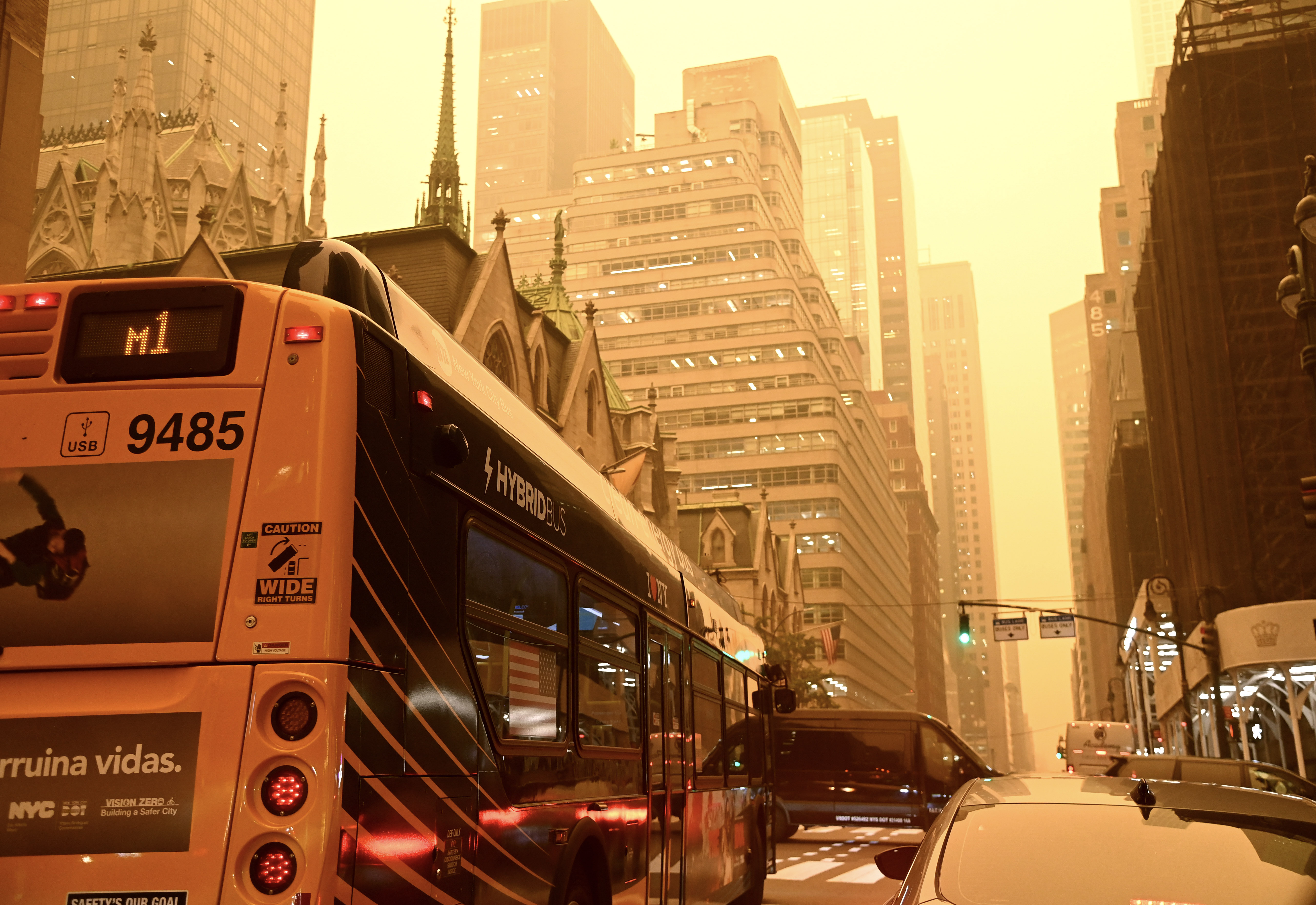
Canada's 2023 fire season burned roughly 15 million hectares. The 2025 season was the second-worst on record, burning about 8.9 million hectares. By August 18, 2026, Canada had recorded 4,793 fires and about 4.1 million hectares burned. These totals are dramatic, but the number alone does not explain the geography.
Fire is a natural ecological process in many North American environments. Decades of suppression can allow fuels to accumulate. Logging, settlement, power lines, roads, invasive species, and land-management choices alter risk. Climate change can lengthen fire seasons and intensify hot, dry conditions. Indigenous cultural burning brings knowledge developed through long relationships with specific landscapes, although colonial governments often suppressed those practices.
The useful distinction is between hazard and vulnerability . Lightning may ignite a fire. Vegetation and management shape the fuel. Weather and climate influence severity. Housing patterns determine exposure. Smoke follows atmospheric pathways. A physical event becomes a disaster through its encounter with human vulnerability.
Climate Change Does Not Replace the Weather
Climate change does not mean that every year becomes steadily warmer in every place. North America will still experience cold waves, wet seasons, unusually mild years, local records, and natural variability. Climate is the distribution within which weather happens. Change the distribution and the odds of different extremes change with it.
Canada's average annual temperature increased by about 2.4 degrees Celsius between 1948 and 2024, with winter warming of about 3.7 degrees Celsius. In the United States, heat, heavy precipitation, coastal flooding, drought, wildfire, and declining snowpack vary sharply by region. National averages can conceal completely different local experiences occurring at the same time.
Climate change arrives through geography that already exists. Heat is more dangerous in neighborhoods with fewer trees and more pavement. Flood losses increase where wetlands have been filled and development has spread into floodplains. Drought becomes a political crisis where legal water promises exceed what a warmer river supplies. Wildfire becomes a housing disaster where development spreads into fire-prone vegetation.
What to carry forward
- North America's physical geography is a system: air, mountains, oceans, rivers, soils, and ice continually interact across political borders.
- The western cordillera helps create both wet windward environments and dry rain-shadow interiors, while the open central plains allow Gulf and Arctic air to move far across the continent.
- Water abundance does not eliminate water politics. Watersheds connect jurisdictions, and the Colorado River shows how climate, law, agriculture, cities, and Indigenous rights become one geographic problem.
- The Arctic is an inhabited homeland. Climate change affects infrastructure and ecosystems, but also travel, livelihoods, sovereignty, and outside access to northern places.
- Hazards become disasters through vulnerability. Wildfire, drought, heat, and flood losses depend partly on where and how people have built landscapes.
- Climate change does not replace ordinary weather. It changes the background conditions and probabilities within which weather continues to occur.
Vocabulary for the section
Works cited and data sources
- Fouberg, Erin H., and William G. Moseley. Understanding World Regional Geography, 2nd ed. Wiley, 2018.
- Environment and Climate Change Canada. Temperature Change in Canada. Current indicator reports a 2.4 C national annual warming trend from 1948-2024 and 3.7 C winter warming.
- Public Safety Canada. 2026 Wildfire Season - August Update, August 18, 2026.
- Environment and Climate Change Canada. Canada's Top 10 Weather Stories of 2025.
- U.S. Environmental Protection Agency. Great Lakes Facts and Figures.
- International Joint Commission. Great Lakes Water Quality.
- NASA Earth Observatory. Lake Mead Keeps Dropping.
Further reading
- National Climate Assessment. Fifth National Climate Assessment, regional chapters for the United States.
- Government of Canada. Canada's Changing Climate Report and continuing national climate indicators.
- Great Lakes Water Quality Agreement resources from the International Joint Commission and U.S. EPA.
The physical continent is only the beginning. The next section asks how Indigenous sovereignty, settler colonialism, slavery, migration, language, race, and national stories have produced overlapping human geographies across the United States and Canada.


Comments
Post a Comment