6.3 South Asia: Empire Drew the Lines
Empire Drew the Lines
How did trade become empire, identity become administration, and hurried colonial borders become states people still live with?

Learning objectives
After reading this section, you should be able to:
- Explain how European commercial activity developed into British territorial rule.
- Distinguish between directly governed British provinces and indirectly governed princely states.
- Describe how colonial surveys, censuses, and political institutions altered the meaning of identity.
- Compare the competing visions of independence advanced by Gandhi, Nehru, Jinnah, Ambedkar, and other South Asian leaders.
- Explain how Partition created India and Pakistan through borders, violence, and mass migration.
- Analyze why religion alone could not hold East and West Pakistan together.
- Compare how South Asian states have addressed federalism, ethnicity, regional autonomy, and disputed borders.
When Difference Acquired Borders
South Asians did not suddenly become different when modern borders appeared. Languages, religions, caste communities, kingdoms, and regional identities had overlapped for centuries. What changed was the machinery surrounding those differences.
Colonial governments surveyed land, counted people, designated majorities and minorities, and attached political consequences to identity. Nationalists then argued over who constituted a nation and what territory it should possess. Britain did not invent caste or religion, but it reorganized them through censuses, law, bureaucracy, and representation. Those institutions survived independence in railways, armies, civil services, property systems, provinces, and borders (Bose & Jalal, 2018; Dirks, 2001).
Before Europe Arrived
European histories once treated Vasco da Gama’s arrival in 1498 as the moment South Asia entered world trade. The world had arrived considerably earlier. Monsoon winds connected East Africa, Arabia, Persia, India, Sri Lanka, Southeast Asia, and China. Gujarati, Tamil, Arab, Persian, Malay, African, Armenian, Jewish, and Chinese merchants operated ships, credit networks, warehouses, and family partnerships across the ocean.

The Portuguese entered this old commercial world with heavily armed ships and attempted to redirect it. Later Dutch, French, Danish, and English companies established settlements of their own. These ventures reflected mercantilism. A chartered company could trade, negotiate, fortify ports, and exercise powers normally associated with states. A warehouse could become the first room of a future government.
The Company That Became a State
The English East India Company, chartered in 1600, established fortified settlements and recruited armies composed largely of Indian soldiers. Its transformation followed a practical chain: goods required warehouses; warehouses required protection; protection required soldiers; soldiers required revenue; revenue required control of land and taxation.
How a Company Became a State
Select a stage to see how commerce accumulated military, fiscal, territorial, and legal powers. The bars are a conceptual teaching model of functions accumulating, not measured percentages.
Goods create a foothold
The Company seeks textiles, spices, saltpeter, and other commodities. Trade depends on rulers, merchants, port officials, financiers, and local labor.
New dependency: Reliable places to store and ship goods.
Functions accumulated
Teaching-model note: the power bars visualize the accumulation of governing functions. They are intentionally qualitative and should not be read as historical percentages.
After the Battle of Plassey in 1757, the Company gained extraordinary influence in Bengal. In 1765 it received the diwani, the authority to collect land revenue in Bengal, Bihar, and Orissa.

Indian taxes could now purchase Indian goods, finance the Company’s army, reward shareholders, and support further conquest. Conquest produced revenue, revenue maintained the army, and the army made further conquest possible. British rule depended heavily on Indian intermediaries. That does not make it less colonial. It reveals how colonial systems penetrate societies rather than remaining entirely outside them.
The Rebellion of 1857
In 1857, Indian soldiers rebelled at Meerut, and the uprising spread across much of northern and central India. Rumored rifle-cartridge grease offended Hindu and Muslim religious practices, but grievances also included military service, taxation, land seizures, annexations, missionary activity, and fears that Company rule threatened established institutions.

After brutally suppressing the uprising, Britain abolished Company rule in 1858 and transferred authority to the Crown. The period that followed became the British Raj. The Company had become too politically powerful to remain merely a company. Britain’s solution was not to end colonial government but to nationalize it.
The Raj and the Contradictions of Infrastructure
The Raj expanded railways, ports, telegraphs, canals, postal systems, and bureaucracies. These systems later provided public benefits, but they were designed first for imperial purposes. Railways moved troops and carried cotton, wheat, tea, and coal toward ports. Telegraphs transmitted commands. Education trained clerks for colonial administration.
Yet infrastructure exceeds its builders’ intentions. The railway that moved soldiers also carried migrants, students, newspapers, lawyers, and nationalists. The telegraph that served imperial command helped create awareness across a vast region.
Colonial taxation and commercial agriculture also connected rural households to landlords, moneylenders, officials, and distant markets. During the Bengal famine of 1943, wartime disruption, inflation, unequal access to food, and administrative failure contributed to millions of deaths. A shortage is physical. A famine is political geography: food in one place, hunger in another, and institutions deciding which movement receives priority (Sen, 1981).
British Provinces and Princely States
Colonial South Asia was a patchwork of directly governed provinces and more than 500 indirectly governed princely states. Together the states covered almost half the subcontinent and contained roughly one-quarter of its population (Ramusack, 2004).
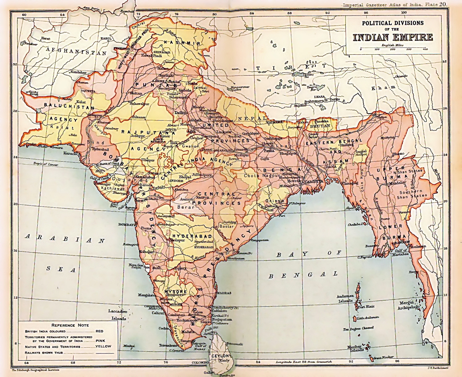
Princes might control local taxation, policing, courts, education, and public works, while Britain controlled defense, foreign relations, and major communications through paramountcy. When Britain withdrew, most rulers lacked the capacity or geography for real independence. Junagadh, Hyderabad, and Jammu and Kashmir became especially controversial because the ruler’s preference, population, and territorial location pointed in different directions.
Counting People, Hardening Categories
Colonial states wanted societies to become legible. Officials surveyed fields, mapped forests, classified occupations, and conducted censuses. Measurement could expose inequality, but it could also convert flexible or disputed identities into official facts.
A multilingual person might be required to name one mother tongue. A changing caste status might receive a fixed classification. Religious practices blending local, Hindu, Muslim, Buddhist, or Indigenous traditions might be placed in one official box. Once printed in a report or colored on a map, a provisional judgment could begin to resemble an ancient fact.
Beginning in 1909, Muslim voters selected Muslim representatives through separate electorates. Supporters saw minority protection; critics saw institutions encouraging politicians to speak as religious blocs. Both concerns were real. This cannot be reduced to one scheme called “divide and rule,” because regional interests and genuine fears of majority domination also mattered.
Competing Visions of Independence
The Indian National Congress eventually became the largest organization demanding independence. The All-India Muslim League sought to protect Muslim political interests and later led the movement for Pakistan. Neither represented everyone it claimed to speak for. The struggle contained several arguments: how empire should end, how power should be distributed, whether minorities could trust majority government, and whether political independence would transform social hierarchy.
Mohandas Gandhi developed satyagraha. In 1930 he walked about 240 miles to Dandi to challenge Britain’s salt monopoly. Salt joined the coastline, the human body, household necessity, colonial law, and imperial authority in one ordinary object.

Gandhi inspired mass participation but was not the sole author of independence or beyond criticism. His views on caste remained contested, his village-centered economics conflicted with industrial visions, and revolutionaries considered nonviolence inadequate. Women including Sarojini Naidu and Aruna Asaf Ali, along with thousands whose names are less remembered, organized marches, boycotts, unions, and underground networks.
Jawaharlal Nehru wanted a secular, democratic, planned, and scientifically oriented India. Muhammad Ali Jinnah feared Muslims would become a permanent minority under a Hindu-majority state. B. R. Ambedkar feared that replacing British rulers with Indian elites would leave caste domination intact. Nehru feared fragmentation. Jinnah feared permanent minority status. Ambedkar feared political democracy without social democracy.
Partition: The Violence of a Line
By the 1940s, Congress, the Muslim League, Britain, and regional leaders had failed to agree on a constitutional future. Britain, exhausted by World War II, decided to withdraw quickly and divide British India into India and Pakistan. Pakistan would begin as two wings separated by more than 1,000 miles of Indian territory.
The Five-Week Border
Move through the final timetable. Independence arrived before many people knew which country would contain their district, railway, canal, farm, or sacred site. The countdown uses the actual 1947 timetable; the unresolved items summarize the kinds of geographic decisions compressed into it.
The decision is public, the boundary is not
Britain announces a rapid transfer of power and possible division of Punjab and Bengal. The future border remains unsettled.
Still unresolved: Mixed districts, irrigation networks, railways, military facilities, and sacred sites.
days until the Radcliffe Award is published
Speed did not simplify the landscape. It reduced the time available to understand it.
Cyril Radcliffe, a British lawyer who had never visited India, received roughly five weeks to divide Punjab and Bengal. The boundary was not announced until after independence ceremonies had begun. Villages, workers, canal systems, railways, farmland, and sacred sites waited for a line that no map could make socially clean.

The Radcliffe Line did not merely separate two settled nations. The movement and violence surrounding it helped create them. About 14 million people crossed the new borders. Estimates of the dead range from several hundred thousand to roughly one million or more. Women suffered abduction, assault, forced marriage, conversion, and murder on a vast scale (Butalia, 1998; Khan, 2007; Talbot & Singh, 2009).
Partition was not inevitable simply because Hindus and Muslims were different. Decades of political competition, fear, institutional separation, propaganda, and hurried withdrawal transformed older differences. The violence then made India and Pakistan more religiously uniform than they had been before.
Kashmir: An Unfinished Partition
Jammu and Kashmir had a Hindu ruler, a majority-Muslim population, and an initial attempt at independence. After fighters from Pakistan entered in 1947, the ruler acceded to India. War produced a ceasefire line, later the Line of Control. India, Pakistan, and China now administer different portions.

In 2019, India revoked Jammu and Kashmir’s special constitutional status and divided the former state into two union territories. The Supreme Court upheld the constitutional change in 2023. Assembly elections returned in 2024, but statehood had still not been restored by August 2026; the Indian government continued to say restoration would come at an “appropriate time” without announcing a deadline (Reuters, 2026d).
Pakistan Divided by India
Pakistan’s two wings differed in language, history, economy, and political power. East Pakistan contained more people, most of them Bengali speakers. West Pakistan contained the capital, senior military leadership, and a disproportionate share of state investment.

The Bengali Language Movement, unequal investment, and the weak response to Cyclone Bhola deepened anger. In the 1970 election, the Awami League won an overall parliamentary majority. Leaders in West Pakistan refused to transfer power, and the army began a violent crackdown. India later intervened, and East Pakistan became Bangladesh in December 1971 (Raghavan, 2013).
Bangladesh demonstrated that shared religion could not erase language, regional inequality, electoral exclusion, or the geography of state power.
Bangladesh and the Continuing Practice of Democracy
Sheikh Hasina governed from 2009 to 2024, combining infrastructure and social gains with increasingly authoritarian rule. A student-led uprising in 2024 forced her resignation. A United Nations investigation estimated that as many as 1,400 people may have been killed during the repression (OHCHR, 2025a).
An interim government headed by Muhammad Yunus oversaw the transition to elections. In February 2026, the Bangladesh Nationalist Party-led coalition won 212 of the 300 directly elected parliamentary seats. Tarique Rahman was sworn in as prime minister on February 17. Elected government returned, but disputes over accountability and political inclusion remained, and the Awami League was still banned in August 2026 (Reuters, 2026a, 2026b, 2026e).
Governing Diversity After Empire
South Asia’s populations rarely matched state borders neatly. Governments therefore had to decide whether to distribute power, recognize languages, redraw internal boundaries, or concentrate authority at the center.
India
Linguistic states often made the union more acceptable rather than breaking it apart. Federalism now coexists with a sharper conflict between India’s secular constitutional framework and Hindu nationalism.
Pakistan
Military authority and strong provincial differences remain central. In Balochistan, gas, minerals, ports, and strategic projects have intensified disputes over who controls resources and who receives the benefits.
Sri Lanka
The Sinhala Only Act and later policies deepened Tamil exclusion. The Tamil Tigers and the state committed grave abuses. War ended in 2009, but accountability, land, and regional autonomy remained unresolved (OHCHR, 2025b).
Nepal
Insurgency, monarchy’s abolition, and a federal constitution transformed the state. After the youth-led anti-corruption protests of 2025, Balendra Shah’s Rastriya Swatantra Party won 182 of 275 parliamentary seats in March 2026. Shah became prime minister on March 27 (Reuters, 2026c).
Bhutan
A constitutional monarchy protects a distinctive Buddhist national culture, yet policies of uniform identity contributed to the flight or expulsion of more than 100,000 Nepali-speaking Lhotshampa.
Maldives
Scattered islands require government across large areas of ocean. Competitive elections since 2008 opened political space, while disputes over courts, executive power, and opposition rights continue.
Afghanistan
The colonial Durand Line divides Pashtun and Baloch communities. The Taliban’s return in 2021 produced territorial control without an elected legislature or an end to severe restrictions on women and public life.
Borders That Never Became Ordinary
| Boundary | What it separates | Why it remains unsettled |
|---|---|---|
| Line of Control | Indian- and Pakistani-administered Kashmir | It emerged from war and ceasefire rather than mutual recognition as a permanent border. |
| Line of Actual Control | Indian- and Chinese-controlled Himalayan territory | Its exact location is disputed. The 2024 disengagement agreements reduced immediate friction at major eastern Ladakh flashpoints, but did not settle the boundary; talks continued afterward. |
| Durand Line | Afghanistan and Pakistan | The colonial frontier divides Pashtun and Baloch communities and has never been fully accepted by successive Afghan governments. |
On a classroom map, these boundaries are thin symbols. On the ground, they become fences, mountain posts, checkpoints, artillery positions, disrupted grazing routes, and families waiting for permission to cross. Borders are political decisions imposed on landscapes where languages overlap, rivers move, and people seldom arrange themselves into clean national blocks.
The Lines and What People Made of Them
Empire remained in law codes, railways, military institutions, civil services, censuses, property arrangements, and borders. Yet South Asian countries are not merely colonial leftovers. Their citizens integrated kingdoms, wrote constitutions, reorganized provinces, abolished monarchies, fought civil wars, built democracies, endured dictatorships, and created new countries.
These histories cannot be dismissed as “ancient hatred.” Ancient identities do not conduct censuses, draw electoral districts, purchase artillery, or issue passports. Institutions and leaders do those things. Nor can every failure be blamed indefinitely on Britain. Later governments chose whether to recognize languages, federalize power, suppress opposition, militarize regions, or define citizenship narrowly.
The Main Ideas
- Europe entered an Indian Ocean trading system that already linked Africa and Asia. The East India Company became a territorial state by accumulating warehouses, soldiers, taxation, land, and governing institutions.
- The Raj built railways, telegraphs, surveys, censuses, and bureaucracies for imperial purposes, yet those same networks also connected migrants, newspapers, organizers, and anti-colonial movements.
- Colonial rule did not invent South Asia’s religions, languages, or caste communities, but official counting and separate political institutions could make identities more fixed and more consequential.
- Gandhi, Nehru, Jinnah, Ambedkar, and other leaders agreed that British rule should end while disagreeing profoundly about social hierarchy, minority security, economic development, federalism, and the meaning of political freedom.
- Partition was not simply a line placed between two preexisting nations. A hurried boundary, mass migration, state-building, and violence helped create India and Pakistan as new territorial realities.
- Kashmir, Bangladesh, the Line of Actual Control, and the Durand Line show that inherited borders do not automatically resolve questions of language, ethnicity, autonomy, sovereignty, or belonging.
- Postcolonial governments inherited institutions and frontiers, but later choices about federalism, majority power, regional autonomy, elections, and repression determined what those inheritances became.
Key Terms and Definitions
- British Raj
- Direct rule over most of the Indian subcontinent by the British Crown from 1858 to 1947.
- Colonialism
- Political and economic control of a territory and its people by an outside state or imperial power.
- Diwani
- The authority to collect land revenue, granted to the East India Company in Bengal, Bihar, and Orissa in 1765.
- East India Company
- A British trading corporation that acquired military, taxation, and territorial powers in South Asia.
- Federalism
- A political system in which authority is divided between a national government and regional governments.
- Indian Rebellion of 1857
- A widespread uprising against Company rule involving soldiers, rulers, peasants, and townspeople.
- Line of Actual Control
- The disputed military boundary separating Indian- and Chinese-controlled territory in the Himalayas.
- Line of Control
- The military boundary dividing Indian- and Pakistani-administered portions of Kashmir.
- Majoritarianism
- The use of majority political power to marginalize or subordinate minority communities.
- Mercantilism
- An economic system in which governments seek power and wealth by controlling trade and colonies.
- Nationalism
- The belief that a people sharing an identity, history, or culture should form or control a political community.
- Paramountcy
- Britain’s claimed overriding authority over South Asia’s princely states.
- Partition
- The division of British India into India and Pakistan in 1947.
- Princely state
- A hereditary South Asian kingdom or principality governed indirectly under British paramountcy.
- Radcliffe Line
- The boundary drawn in 1947 to divide Punjab and Bengal between India and Pakistan.
- Satyagraha
- Gandhi’s method of political resistance based on truth, nonviolence, and civil disobedience.
- Separate electorate
- A system in which members of an officially defined community vote separately to choose representatives from that community.
- Sovereignty
- A state’s recognized authority to govern its territory and population.
Thinking Geographically
- Why is it misleading to claim that Europeans introduced South Asia to international trade?
- How did the East India Company develop from a commercial organization into a government?
- Why can the uprising of 1857 be described as a mutiny, rebellion, or war of independence?
- How did colonial infrastructure both support and undermine British rule?
- How did princely states differ from provinces of British India?
- What powers did princely rulers retain, and what powers remained under British control?
- How did colonial censuses make religious, language, and caste identities more politically consequential?
- Why did Nehru, Jinnah, and Ambedkar fear different outcomes after British withdrawal?
- How did Gandhi use the geography of salt to challenge imperial authority?
- Why did the Radcliffe Line help create India and Pakistan rather than simply separating two existing nations?
- Why was religion insufficient to hold East and West Pakistan together?
- How has federalism helped India manage linguistic diversity?
- How did majority rule become majoritarianism in Sri Lanka?
- What do the Line of Control, Line of Actual Control, and Durand Line reveal about drawing versus resolving a border?
- Why is it inadequate to explain South Asian conflicts entirely as either ancient hatreds or products of British colonialism?
Works Cited & Further Reading
- Bayly, C. A. (1988). Indian society and the making of the British Empire. Cambridge University Press.
- Bose, S., & Jalal, A. (2018). Modern South Asia: History, culture, political economy (4th ed.). Routledge.
- Brown, J. M. (2010). Gandhi: Prisoner of hope. Yale University Press.
- Butalia, U. (1998). The other side of silence: Voices from the Partition of India. Duke University Press.
- DeVotta, N. (2004). Blowback: Linguistic nationalism, institutional decay, and ethnic conflict in Sri Lanka. Stanford University Press.
- Dirks, N. B. (2001). Castes of mind: Colonialism and the making of modern India. Princeton University Press.
- Election Commission of India. (2024). Jammu and Kashmir Legislative Assembly election, 2024: Statistical report.
- Fouberg, E. H., & Moseley, W. G. (2017). Understanding world regional geography (2nd ed.). Wiley.
- Government of India. (1956). The States Reorganisation Act, 1956.
- Government of India, Ministry of External Affairs. (2025). Disengagement along the Line of Actual Control between India and China: Lok Sabha question no. 3278. Ministry of External Affairs.
- Hutt, M. (2003). Unbecoming citizens: Culture, nationhood, and the flight of refugees from Bhutan. Oxford University Press.
- Khan, Y. (2007). The great Partition: The making of India and Pakistan. Yale University Press.
- Metcalf, B. D., & Metcalf, T. R. (2012). A concise history of modern India (3rd ed.). Cambridge University Press.
- Office of the United Nations High Commissioner for Human Rights. (2025a). Human rights violations and abuses related to the protests of July and August 2024 in Bangladesh. OHCHR.
- Office of the United Nations High Commissioner for Human Rights. (2025b). Situation of human rights in Sri Lanka (A/HRC/60/21). OHCHR.
- Raghavan, S. (2013). 1971: A global history of the creation of Bangladesh. Harvard University Press.
- Ramusack, B. N. (2004). The Indian princes and their states. Cambridge University Press.
- Sen, A. (1981). Poverty and famines: An essay on entitlement and deprivation. Oxford University Press.
- Supreme Court of India. (2023). In re: Article 370 of the Constitution.
- Talbot, I., & Singh, G. (2009). The Partition of India. Cambridge University Press.
- United Nations Assistance Mission in Afghanistan. (2026). The situation in Afghanistan and its implications for international peace and security. United Nations.
- United Nations General Assembly. (2010). Report of the Working Group on the Universal Periodic Review: Maldives.
- United Nations High Commissioner for Refugees. (2015, November 19). Resettlement of Bhutanese refugees surpasses 100,000 mark.
- Whelpton, J. (2005). A history of Nepal. Cambridge University Press.
- Zamindar, V. F.-Y. (2007). The long Partition and the making of modern South Asia. Columbia University Press.
- Reuters. (2026a, February 13). Bangladesh’s BNP wins two-thirds majority in landmark election. Reuters
- Reuters. (2026b, February 17). Tarique Rahman sworn in as Bangladesh’s prime minister after landslide election victory. Reuters
- Reuters. (2026c, March 27). Ex-rapper Shah sworn in as Nepal prime minister after sweeping election win. Reuters
- Reuters. (2026d, July 20). Hundreds protest in Delhi demanding statehood for Indian-administered Kashmir. Reuters
- Reuters. (2026e, August 16). Bangladesh says better environment needed for India visit amid rift over ousted leader. Reuters
Visual Credits
Open visual and map notes
The nine photographs and maps link to their Wikimedia Commons source pages and retain the listed creator and license information. Historical maps should be read as arguments made for particular audiences, not as neutral windows onto the past.


Comments
Post a Comment